
I was first introduced to the Traveller role-playing game in 1977. It has been one of my favourite role-playing games ever since. From the early days when our parties seemed to consist of nothing but psychopathic nutbars who spaced passengers and stole their belongings, to sector spanning adventures that involved lost starships and halting a Zhodani invasion fleet outflanking the Spinward Marches – I have pretty much played and GM’d all of what Traveller is capable of being – and I am still not tired of it. However, ever since I first played the game the only thing that bugged me was the two dimensional system mapping that was used.
This is a Traveller Sub Sector Map – The Aramis Subsector from the iconic Spinward Marches region of the Official Traveller Universe. For a larger map of the entire region see the great Zhodani Base – a treasure trove of fantastic Traveller resources.
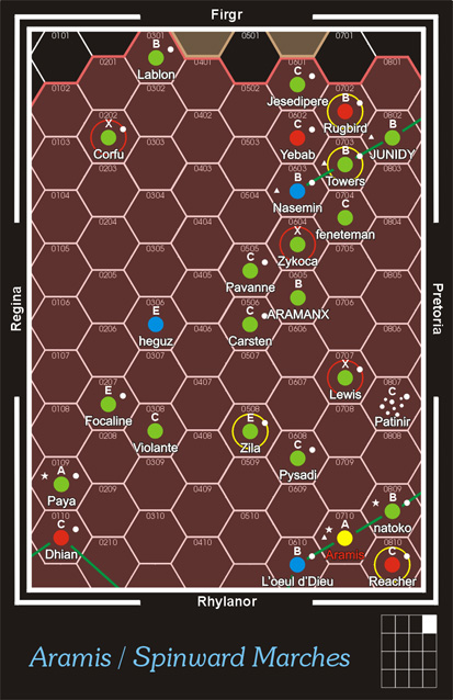
As you can see it is a two dimensional representation of a region of space encompassing an area of some 8×10 (80 square parsecs). Interstellar travel in Traveller is done by ships equipped with Jump Drives. Each hex being a ‘Jump’. Depending on technology levels Jump Drives can move a ship between one and six hexes (or jumps). Conveniently, all Jumps take about a week, give or take. Now, it nowhere specifies that the distance between two systems one hex apart is exactly one parsec so the standard 2D map can be viewed as a type of interstellar railway system map.
Now after many years of playing Traveller I have a heap of starship deck plans and designs already made – using the Classic Traveller module Book Five: High Guard. I didn’t want them all to go to waste. I have decided for my next Traveller game to use a three dimensional Jump map. I have played with this before and tried stacking hex maps but it is ugly and all those hexes do my head in. I have gone for a Sub Sector (or Sector) of 10x10x10 Parsecs (give or take a few).
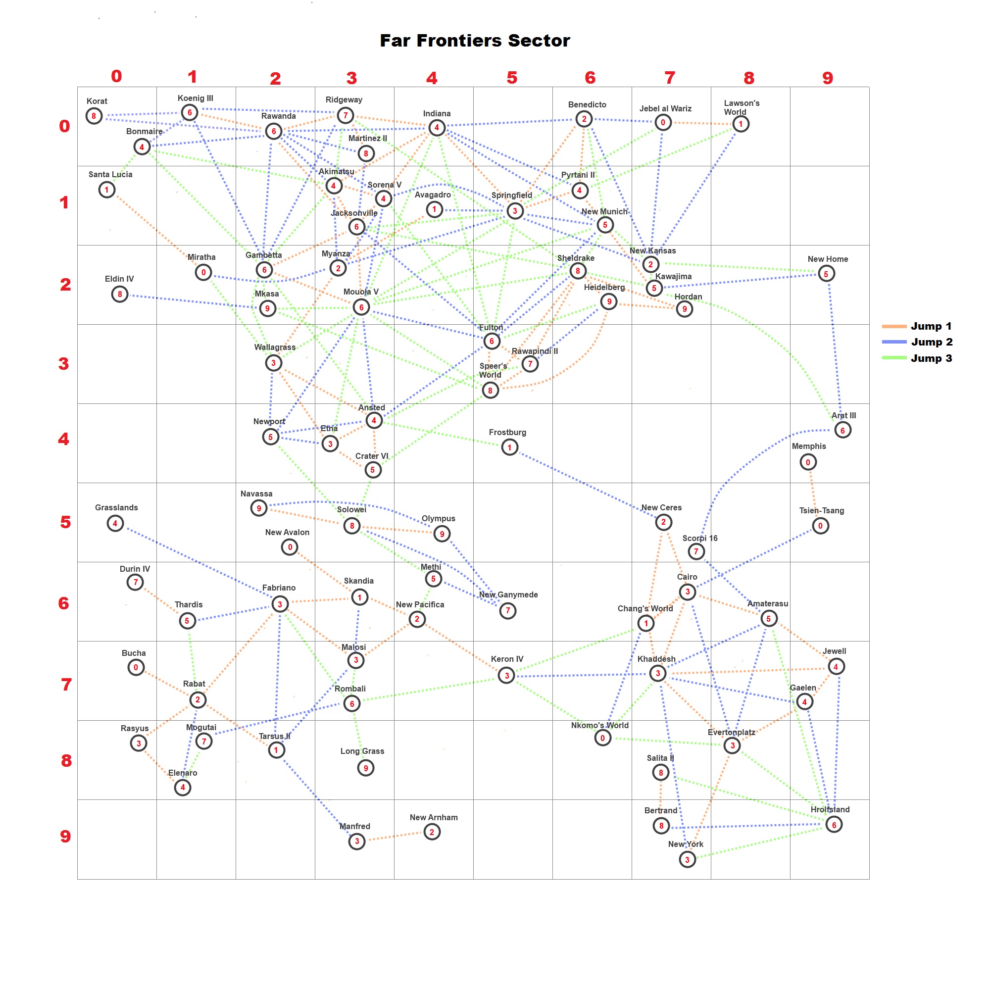
On this 2D map the systems are located by their positions in three dimensions. For example, the Koenig III System is located at 1-0-6 (6 being the the third dimension). I have marked Jump Routes up to J3 (although not all of them) to save time later but to work out the distance in parsecs to any other system, all you need to do is a bit of really basic math. For example, the navigator of a starship wants to plot a course from Koenig III (1-0-6) to Gambetta (2-2-6).
You just need to us this formula:
![]()
For the example above:
Distance = √ ( ( 2-1)² + (2-0)² + (6-6)² )
Distance = √ (1² + 2² + 0² )
Distance = √ (1+4+0)
Distance = √ 5
Distance = 2.236 = The ship has Jump 2 engines installed so can make the jump in one go.
Now using this system I am making the arbitrary assumption that a ship with Jump 1 engines will go up to 1.999 parscecs, with Jump 2 engines 2-2.999 parsecs and so forth.

I like your 3D map. It is readable. Many 3D maps I have seen are so messy. The color coding of the distance is brilliant!
LikeLike
I have long been a fan of your site. I really appreciate your comment.
LikeLike
Great map! What software did you use to create this lovely, clearly readable map? Did you manually position the systems?
If the software is something accessible, would there be a copy of the file that you used?
I’ve built a 3D 20x20x20 LY in Astrosynthesis 3.0, but even then, it isn’t going to be easily accessible to players over the net. However, a nice map like yours could work really well.
How does your map handle two concurrent planets with the same X,Y and yet with different Z coordinates? One would think they’d overlap on 2D map placement…
LikeLike
Glad you like this one. I used PAINT.net – a free piece of shareware. Basically it is MS Paint with layers. As to how the map handled that – I just ever so slightly move one star over a bit 🙂 The joys of being the Creator of my Universe 🙂
LikeLike